Geophysical Investigation

Seismic Refraction Survey:

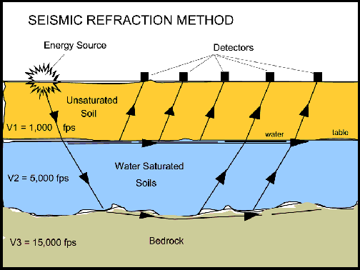
The aim of the Seismic investigation was to provide information regarding the shallow lithology along the surveyed Seismic lines and soil rock profiles.Seismic refraction is a geophysical principle (see refraction) governed by Snell's Law. Seismic Refraction Survey is generally provided by the Geophysical manufacturing and contracting company in india.

Methods

The methods depend on the fact that seismic waves have differing velocities in different types of soil (or rock): in addition, the waves are refracted when they cross the boundary between different types (or conditions) of soil or rock. The methods enable the general soil types and the approximate depth to strata boundaries, or to bedrock, to be determined.

purpose

The purpose of the resistivity imaging survey was to determine and estimate the overburden, rock line and low resistivity zones beneath surface and along the electrical resistivity imaging profile generated by the electrical resistivity imaging Technique. In resistivity imaging we utilize the electric current property for assessment of characteristics of subsurface material. Electric current will always pass through the weak zone.

APPLICATIONS:

  • Rock competence for engineering applications.
  • Depth to Bedrock.
  • Groundwater exploration
  • Correction of lateral, near-surface, variations in seismic reflection surveys
  • Crystal structure and tectonics.